


Description of ViewRanger Trails & Maps
Discover thousands of inspiring trail guides, download detailed Ordnance Survey® maps, and navigate your outdoor adventures with ViewRanger’s integrated navigation system. Share your adventures and inspire others to discover new places! Perfect for exploring mountain peaks or simply days out in the countryside.
Used and trusted by over 250 search and rescue teams.
'Google Play' - #1 Outdoor App
'The Great Outdoors'- Best Buy 5 stars
'The Sunday Times'- selected ViewRanger as one of their "five-star must have applications, in their guide to the best apps of the year.
'T3 Magazine'- The ultimate off road GPS guide software that not only takes you places, but shows you what’s there on arrival!
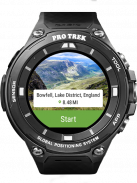
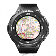
ANDROID WEAR™
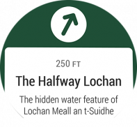
• Navigate your trail and view track stats on your wrist with Android Wear™ enabled smartwatches.
• Record a new track and pause or stop an existing track recording.
• View Heading, Bearing, Lat/Long and Altitude data.
SKYLINE: AUGMENTED REALITY FOR THE OUTDOORS
Bring your outdoor map to life with Skyline, our new augmented reality technology. Using the camera it will identify key features around you such as peaks, places and lakes. Skyline helps you navigate too. See waypoints and follow direction arrows for routes on the real landscape.
[Skyline requires devices with GPS capabilities, phone camera, compass, and gyro sensors. Compatibility with Skyline is not guaranteed.]
FEATURES:
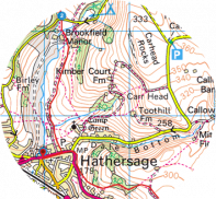
DOWNLOAD ORDNANCE SURVEY® MAPS & MORE: Great Britain Ordnance Survey® Explorer 1:25,000 & Landranger 1:50,000 maps; OpenStreetMap®, OpenCycleMap, Bing Aerial Imagery Ski piste map and transport maps.
PLANNING A TRIP ABROAD? WE HAVE YOU COVERED
Download the best topographic maps for your travels across many countries in Europe, North America and also New Zealand. See the full list of countries in the map shop.
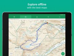
ACCURATE OFFLINE NAVIGATION: The app uses your device's GPS, and does not need data or mobile signal to locate you on a map, record your track, or follow a route. Maps are stored on your phone so they work offline.
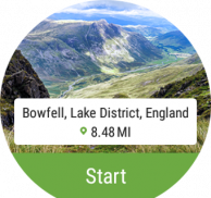
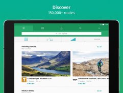
DISCOVER INSPIRING TRAIL GUIDES: Create and follow your own routes or download routes from our massive library of expert- and community-generated walks and rides. Discover routes from leading publishers such as MBUK, BBC CountryFile, Walking World, Trail, TGO and many National Parks.
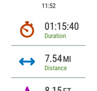
RECORD YOUR ADVENTURE: Record your track, see your track live on the map as you advance and share the completed track with friends; view track stats such as distance, speed, altitude and many more.
SHARE YOUR LOCATION: BuddyBeacon™ is a unique PIN-protected real-time location sharing and tracking system which allows you to share your location with friends and family.
-------------------------------
SUPPORT
Need more info? visit: http://www.viewranger.com
Support page: http://www.viewranger.com/en-us/support
Any questions or feedback, please drop us an email: support@viewranger.com
OTHER
Free Global maps © OpenStreetMap contributors.
Some features such as BuddyBeacon, viewing online maps, browsing route suggestions, downloading maps and routes requires an internet connection.</br></br></br></br></br></br></br></br></br></br></br></br></br></br></br></br></br></br></br></br></br></br></br></br></br></br></br></br></br></br></br></br></br></br></br></br></br></br></br></br></br>
ViewRanger Trails & Maps - Version 10.11.66
(01-12-2021)

ViewRanger Trails & Maps - APK Information
APK Version: 10.11.66Package: com.augmentra.viewranger.androidApps in the same category
You may also like...


